Well, the 11 inches of snow that occurred last Friday is nothing but a distant memory now. High temps in the lower 70's on Sunday along with SW winds of 20-30 mph gobbled up nearly every bit of the snow. Now, let's get to bigger and better things.
This weekend holds the potential for a descent chase somewhere in the central plains. Obviously it's too far out for details, but the GFS brings a strong low pressure system onto the plains somewhere in the Friday to Saturday time frame. The best thing about this is, I'm off!!! I have been on one mediocre chase this year, so it's time for mother nature to ante up and bring me some good stuff to chase.
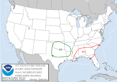
The SPC is already beginning to paint in areas that may be affected this weekend. They are basically saying that due to robust return flow and adequate winds in the atmosphere by day 6, the pattern is conducive to a potential severe weather outbreak over portions of the S central CONUS. That's pretty strong wording this far out!
I will definitely be giving updates to this potential chase, so check back often!


1 comment:
Well that didnt last long. I mean the snow AND our chase potential this weekend.. medeocre moisture and bad timing has all but killed saturday for us. I was hoping a nice drylien chase along the tx/ok border but these massive cold fronts keep sweeping the gulf clean. It will take a few weeks for a descent deep moisture supply to get back up this way. We have seen this pattern before.
Post a Comment